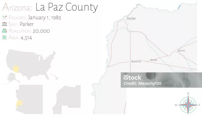
La Paz County, one of Arizona’s hidden gems, occupies a unique position in the state’s geography. Established in 1983, it’s Arizona’s newest county and offers a fascinating blend of desert landscapes, Colorado River access, and rich mining history. This comprehensive guide will help you locate La Paz County on an Arizona map while exploring its geographical significance, neighboring regions, transportation routes, and notable landmarks.
Geographical Location and Coordinates
La Paz County sits in western Arizona with distinct geographical characteristics:
- Coordinates: 33.8°N latitude, 113.9°W longitude
- Position in Arizona: Western border region, about 130 miles west of Phoenix
- Elevation Range: From 250 feet along the Colorado River to 4,000 feet in eastern mountain areas
- Area Coverage: 4,513 square miles (11,690 km²), making it Arizona’s 5th largest county
The county’s location places it firmly within the Sonoran Desert ecosystem.
County Seat and Major Towns
The county seat of La Paz County is Parker, located along the Colorado River. Other notable towns and communities within the county include:
- Quartzsite – Known for its annual gem and mineral show.
- Salome – A small town with a rich history.
- Wenden – Located in the McMullen Valley.
- Bouse – A community with historical significance.
- Ehrenberg – Situated near the California border.
- Cibola – Close to the Cibola National Wildlife Refuge.
- Poston – Known for its historical internment camp during World War II.
- Brenda – A small community with a rural setting.
- Bluewater – A census-designated place with scenic views.
- Vicksburg – A historic town with mining roots.
- La Paz Valley – A region with agricultural significance.
- Parker Strip – A popular area for water recreation.
- Alamo Lake – Known for its state park and outdoor activities.
- Cienega Springs – A community with natural springs.
- Utting – A small settlement with historical ties.
- Sunwest – A community with a focus on solar energy.
Historical Context
La Paz County was established on January 1, 1983, after voters approved separating the northern portion of Yuma County. This makes it the only county in Arizona to be established after the state became a part of the United States. The name “La Paz” is derived from a Spanish term meaning “the peace,” reflecting the area’s tranquil setting along the Colorado River.
Before its establishment, the area was part of Yuma County. The decision to create La Paz County was influenced by the desire for more localized governance and the recognition of the unique needs of the western region of Arizona.
Position Relative to Major Arizona Cities
Understanding La Paz County’s location requires context from nearby urban centers:
- Phoenix: Approximately 130 miles east (2.5 hour drive)
- Yuma: About 80 miles south via US-95
- Lake Havasu City: 60 miles northwest, just beyond the county line
- Parker: The county seat sits right on the Colorado River
This positioning makes La Paz County a gateway between Arizona’s major western destinations.
Bordering Counties and States
La Paz County shares boundaries with several important regions:
- North: Mohave County (home to Kingman)
- East: Yavapai County and Maricopa County
- South: Yuma County
- West: Colorado River forms natural border with California
- Notable Neighbor: Borders Riverside County, California across the river
These borders create interesting cultural and economic connections.
Highways and Transportation Routes
Key roads help locate La Paz County on any Arizona map:
- US Highway 60: Runs east-west through northern part of county
- US Highway 95: Major north-south artery along western edge
- Arizona State Route 72: Connects Parker to Interstate 10
- Colorado River Indian Tribes Route 1: Important local road
These transportation corridors define the county’s accessibility and economic links.
Notable Landmarks and Natural Features
Several physical features make La Paz County easy to identify on maps:
- Colorado River: Forms the entire western boundary
- Bill Williams River: Flows into Colorado River at Parker
- Bouse Mountains: Visible eastern boundary marker
- Alamo Lake: Large reservoir in eastern county
- Parker Dam: Engineering landmark on the Colorado River
These features create distinct visual reference points for map identification.
Comparison to Other Arizona Counties
La Paz County stands out in several ways:
- Population Density: Only 7 people per square mile (state average is 57)
- Land Use: 85% public lands (BLM and state trust lands)
- Economic Focus: Tourism and recreation dominate vs. urban counties
- Geological Features: Contains parts of three distinct desert regions
These characteristics make it visually distinct on thematic maps of Arizona.
Conclusion
La Paz County occupies a distinctive position in western Arizona, bordered by the Colorado River and encompassing vast Sonoran Desert landscapes. Located between Phoenix and California, it’s easily identifiable on maps by its river boundary, major highways, and unique landmarks like Parker Dam. While often overlooked compared to Arizona’s more populous counties, La Paz County offers important recreational and ecological resources. Whether you’re studying an Arizona roadmap or planning a desert adventure, understanding La Paz County’s geographical context enhances your appreciation of this remarkable region.

