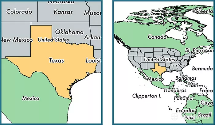
Texas occupies a central position in the southern United States, making it one of the most strategically located states in the nation. When you look at a map of the United States, you’ll find Texas in the south-central portion of the country, sharing borders with four U.S. states and the nation of Mexico. This prime location has shaped Texas’ history, culture, and economy in profound ways.
The state stretches approximately 790 miles from east to west and 660 miles from north to south, covering a total area of 268,596 square miles. This makes Texas the second-largest state in the U.S. after Alaska. Its massive size means it contains diverse landscapes ranging from coastal plains to high deserts.
Exact Coordinates and Bordering Regions
Latitude and Longitude
- 25°50’N to 36°30’N latitude
- 93°31’W to 106°38’W longitude
This places the state entirely within the northern and western hemispheres. The geographic center of Texas is located in McCulloch County, near the city of Brady.
Neighboring States and Countries
- Oklahoma (north)
- New Mexico (west)
- Louisiana (east)
- Arkansas (northeast)
- Mexico (south)
The Rio Grande River forms about 1,254 miles of the international boundary between Texas and Mexico. This border region is culturally vibrant and economically significant.
Physical Geography and Major Landforms
Coastal Plains
The Gulf Coastal Plains cover the eastern third of Texas, extending inland about 250 miles from the coastline. This region features:
- Flat to gently rolling terrain
- Numerous rivers flowing southeast to the Gulf
- Fertile soils ideal for agriculture
- Major cities like Houston and Corpus Christi
Central Plains
- The rolling prairies of North Texas
- The limestone-rich Hill Country around Austin
- The Cross Timbers area with its mix of forest and prairie
- Major cities like Dallas-Fort Worth and Austin
Great Plains
- High flatlands in the Panhandle
- The dramatic Caprock Escarpment
- Palo Duro Canyon (second largest canyon in the U.S.)
- Major agricultural areas for cotton and wheat
Mountains and Basins
- The rugged Trans-Pecos region
- The Guadalupe Mountains (highest point in Texas at 8,749 feet)
- The Chihuahuan Desert
- Big Bend National Park along the Rio Grande
Climate Zones Across Texas
Eastern Texas Climate
- Humid subtropical climate
- Annual rainfall of 40-60 inches
- Hot summers, mild winters
- Frequent thunderstorms and hurricane risk
Central Texas Climate
- Transitional climate between humid and arid
- 25-40 inches annual rainfall
- Hot summers with occasional droughts
- Mild winters with occasional freezes
Western Texas Climate
- Semi-arid to arid climate
- Less than 20 inches annual rainfall
- Extreme temperature variations
- Low humidity and frequent winds
Cultural Regions of Texas
East Texas Culture
- Southern U.S. traditions
- African American heritage
- Cajun influences near Louisiana
- Strong Baptist religious presence
Central Texas Culture
- Blend of Southern and Western traditions
- German and Czech influences
- Live music scene in Austin
- High-tech economy in major cities
South Texas Culture
- Strong Mexican-American influence
- Tejano music and culture
- Cattle ranching traditions
- Bilingual communities
West Texas Culture
- Cowboy and ranching heritage
- Frontier mentality
- Mexican border influences
- Artistic communities like Marfa
Economic Importance of Texas’ Location
Energy Production
- Oil production (Permian Basin, Eagle Ford Shale)
- Natural gas production
- Wind energy generation
- Solar energy potential
Agricultural Output
- Cattle and livestock (Panhandle)
- Cotton (High Plains)
- Citrus fruits (Rio Grande Valley)
- Vegetables (Winter Garden region)
International Trade
- Busy border crossings with Mexico
- Deepwater ports like Houston
- Extensive highway and rail networks
- International airports in major cities
Technology and Manufacturing
- Silicon Hills tech sector in Austin
- Aerospace industry in Fort Worth
- Medical research in Houston
- Computer manufacturing in Round Rock
Ecological Diversity Across Texas
Gulf Coast Ecosystems
- Coastal marshes and wetlands
- Barrier islands
- Estuaries supporting shrimp and fish
- Migratory bird habitats
Piney Woods Ecology
- Dense pine forests
- Hardwood bottomlands
- Diverse wildlife including bears and birds
- Important timber resources
Prairie Ecosystems
- Tallgrass prairies (now mostly converted)
- Shortgrass prairies in Panhandle
- Bison herds (historically)
- Prairie chicken habitats
Desert Ecosystems
- Chihuahuan Desert flora and fauna
- Unique cacti and succulents
- Desert-adapted wildlife
- Fragile soils vulnerable to erosion
Transportation Networks in Texas
Highway System
- Extensive interstate highways (I-10, I-20, I-35, I-45)
- The longest highway system in the U.S.
- Major trucking routes for commerce
- Growing traffic congestion in urban areas
Rail Network
- Major freight rail corridors
- Amtrak passenger service (limited)
- Urban light rail in Dallas and Houston
- Connections to Mexican rail system
Air Travel
- Two of nation’s busiest airports (DFW, IAH)
- Regional airports across state
- Growing international connections
- Spaceport development in South Texas
Water Transportation
- Houston Ship Channel (busiest U.S. port)
- Other deepwater ports like Corpus Christi
- Inland waterways on major rivers
- Growing cruise ship industry in Galveston
Conclusion
This central location has made Texas an economic powerhouse and cultural melting pot. Understanding where Texas is on the map helps explain why it has become such an influential state in the nation’s history and current affairs.
From the pine forests of the east to the deserts of the west, from the Gulf Coast to the Panhandle, Texas offers remarkable geographic diversity within its borders. This variety of landscapes and ecosystems supports an equally diverse population and economy.
As Texas continues to grow and evolve, its strategic location will ensure it remains a vital center of commerce, culture, and innovation in the 21st century. Whether you’re interested in history, business, nature, or culture, knowing where Texas is located provides essential context for understanding this dynamic state.

