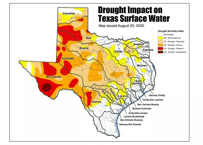
Texas, with its vast landmass and diverse geography, is home to several regions that experience varying degrees of aridity. From the humid coastal plains to the parched desert landscapes in the west, the state offers a stark contrast in its climates. In this article, we will explore the five driest regions of Texas, what makes them so arid, and how their climate impacts the people, agriculture, and wildlife in those areas.
1. The Trans-Pecos Region
The Trans-Pecos region, located in far West Texas, is considered the driest part of the state. This area, which includes cities like El Paso and Marfa, is dominated by the Chihuahuan Desert.
- Rainfall: The Trans-Pecos averages less than 10 inches of rainfall annually, which is extremely low compared to the state average of 30 inches.
- Geography: The region consists of rugged mountains, deserts, and vast plains. The Davis Mountains and Big Bend National Park are notable features.
- Temperature: Summers can reach over 100°F, while winters are generally mild with occasional cold fronts.
- Impact: Due to the dry conditions, agriculture in this region is mostly limited to drought-resistant crops, and ranching is a common industry.
2. The High Plains
The High Plains, located in the northern part of Texas, includes the Texas Panhandle and the Llano Estacado. This region is characterized by flat, expansive plains with low rainfall.
- Rainfall: The High Plains receive between 14 to 20 inches of rain annually, making it semi-arid but still one of the drier regions in the state.
- Geography: The High Plains are known for their flat topography, with large stretches of farmland and grasslands.
- Climate: Summers can be scorching, and winter temperatures can dip below freezing, causing a drastic contrast in the weather.
- Water Supply: This region relies heavily on underground aquifers, like the Ogallala Aquifer, for irrigation and water supply.
3. The South Plains
The South Plains, located south of the High Plains, includes towns such as Lubbock and Plainview. This region also experiences dry conditions but with slightly higher rainfall than the Trans-Pecos and High Plains.
- Rainfall: The South Plains receives about 18 inches of rain annually, still far less than the average for most of the state.
- Geography: This region consists mainly of flat land, with some rolling hills and large stretches of farmland.
- Climate: Summers are hot and dry, while winters are typically cold but not as severe as in the High Plains.
- Agriculture: Cotton farming is a major industry here, as the dry climate is well-suited for crops that require less water.
4. The Rolling Plains
The Rolling Plains, located in the central part of the state, extends from the eastern edge of the High Plains to the western edge of the North Texas region. This area is another one that experiences semi-arid conditions.
- Rainfall: The Rolling Plains receives around 20 inches of rainfall per year, making it drier than the more humid eastern parts of Texas but wetter than the Trans-Pecos.
- Geography: This region is characterized by gently rolling hills, grasslands, and sparse tree cover.
- Climate: The climate is warm and dry during the summer, with cooler temperatures in the winter.
- Impact on Agriculture: The dry conditions limit the types of crops that can be grown, but wheat and cotton are common in this region.
5. The Coastal Bend
While the Coastal Bend is typically known for its humid climate due to its proximity to the Gulf of Mexico, parts of this region can experience dry conditions, especially as you move inland.
- Rainfall: The areas further inland in the Coastal Bend receive less rainfall, averaging around 20 inches annually.
- Geography: The landscape transitions from coastal marshes to flat, dry plains as you move further inland.
- Climate: The Coastal Bend experiences a mix of humid coastal weather and more arid conditions inland, with hot summers and mild winters.
- Impact on Water Resources: The Coastal Bend relies on coastal aquifers and reservoirs, and water scarcity can be an issue during drought years.
What Makes These Regions So Arid?
Several factors contribute to the aridity of these regions, including:
- Geographic Location: Many of the driest regions of Texas are located in the western and northern parts of the state, where there is less influence from the Gulf of Mexico’s moisture.
- Rain Shadow Effect: The mountains in West Texas block moist air from reaching the interior regions, creating dry conditions.
- Latitude: Texas’ location further south means that the sun’s rays are more direct, contributing to higher evaporation rates.
- Wind Patterns: Winds in Texas often come from the west, carrying dry air from the desert regions of Mexico and the Southwestern U.S.
Impact on Texas Communities and Economy
Living in Texas’ driest regions can be challenging, but these areas are adapted in unique ways:
- Agriculture: Farmers in arid regions use techniques like drip irrigation and drought-resistant crops to thrive in dry conditions.
- Water Use: Water conservation is essential, and residents rely on underground aquifers, which are not renewable resources.
- Tourism: Despite the dry conditions, the scenic desert landscapes and national parks like Big Bend attract tourists, boosting the economy in these regions.
Conclusion
Texas’ driest regions, from the Trans-Pecos to the High Plains, are all defined by unique geographical features, low rainfall, and distinct climatic conditions. While these areas face challenges due to their arid environments, they also present opportunities for agriculture, tourism, and renewable energy. Understanding the factors that make these regions so dry helps residents, travelers, and industries make informed decisions about water usage, farming, and land management.

