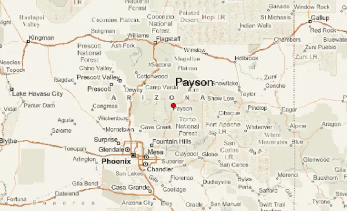
Payson, Arizona, often referred to as “The Heart of Arizona,” is a picturesque town nestled in the central part of the state. Known for its stunning natural beauty, rich history, and vibrant community, Payson offers a unique blend of small-town charm and outdoor adventure. This guide provides an in-depth look at Payson’s location, geography, climate, attractions, and more, offering readers a comprehensive understanding of this captivating destination.
Geographic Location of Payson, AZ
Central Position in Arizona
Payson is situated in northern Gila County, placing it near the geographic center of Arizona. This central location has earned it the nickname “The Heart of Arizona”. The town’s coordinates are approximately 34.2309° N latitude and 111.3251° W longitude.
Proximity to Major Cities
- Phoenix: Approximately 90 miles southwest of Payson, accessible via State Route 87, also known as the Beeline Highway.
- Flagstaff: Roughly 90 miles northwest, offering a scenic drive through Arizona’s diverse landscapes.
- Globe: Located about 80 miles south, Globe serves as the county seat of Gila County.
These proximities make Payson an ideal getaway for residents of larger cities seeking a retreat into nature.
Topography and Natural Surroundings
Elevation and Terrain
Payson sits at an elevation of approximately 5,000 feet (1,524 meters) above sea level. This elevation contributes to its moderate climate and lush vegetation. The town is nestled below the Mogollon Rim, a 200-mile-long escarpment that marks the southern edge of the Colorado Plateau.
Surrounding Natural Features
- Tonto National Forest: Enveloping Payson, this is the largest of Arizona’s six national forests and the ninth-largest in the United States.
- Ponderosa Pine Forests: The area boasts the world’s largest stand of virgin Ponderosa Pines, offering a verdant canopy and diverse wildlife.
- Mountain Lakes and Streams: Numerous cold-water lakes and streams are stocked with fish, making the area a haven for anglers and nature enthusiasts.
Climate and Weather Patterns
Seasonal Overview
Payson experiences a four-season climate, characterized by mild summers and cool winters:
- Summer: Daytime temperatures average in the 80s°F (27-32°C), with cooler nights.
- Winter: Daytime highs typically range from the 40s to 50s°F (4-10°C), with nighttime lows occasionally dipping below freezing.
- Precipitation: The area receives an average annual precipitation of about 22 inches, including occasional snowfall in winter.
This moderate climate makes Payson a year-round destination for outdoor activities.
Transportation and Accessibility
Major Highways
- State Route 87 (Beeline Highway): Connects Payson to Phoenix in the southwest and Winslow in the northeast.
- State Route 260: Runs east-west, linking Payson to Show Low and other eastern Arizona communities.
Public Transportation
The Beeline Bus, operated by the Payson Senior Center, provides local transit services, connecting Payson with neighboring communities such as Star Valley and Mesa del Caballo.
Demographics and Community
Population
As of the 2020 census, Payson had a population of 16,361 residents. The town’s population density is approximately 845 people per square mile, reflecting its small-town atmosphere.
Community Services
Payson offers a range of community services, including:
- Education: Served by the Payson Unified School District and a branch of Gila Community College.
- Public Safety: The Payson Police Department and Fire Department provide comprehensive emergency services.
- Healthcare: Medical facilities and clinics cater to residents’ health needs.
Cultural and Recreational Attractions
Annual Events
- World’s Oldest Continuous Rodeo: Held every August since 1884, this event is a cornerstone of Payson’s cultural heritage.
- Arizona State Old Time Fiddlin’ Championship: A September event celebrating traditional music and attracting participants nationwide.
Outdoor Recreation
Payson is a gateway to numerous outdoor activities:
- Hiking and Biking: Trails like the Horton Creek Trail offer scenic routes through forests and along streams.
- Fishing and Camping: The area’s lakes and campgrounds provide ample opportunities for anglers and campers.
- Tonto Natural Bridge State Park: Home to the world’s largest natural travertine bridge, located just northwest of Payson.
Payson on the Map: Visual Representation
To locate Payson on a map:
- Arizona State Map: Find the central region; Payson is approximately 90 miles northeast of Phoenix.
- Gila County Map: Payson is in the northern part of the county, near the Mogollon Rim.
- Coordinates: 34.2309° N latitude, 111.3251° W longitude.
Online mapping services like Google Maps or MapQuest can provide detailed directions and satellite imagery of Payson.
Conclusion
Payson, Arizona, embodies the essence of a mountain town with its central location, natural beauty, and vibrant community. Whether you’re seeking outdoor adventure, cultural experiences, or a peaceful retreat, Payson offers a diverse array of attractions. Its position near the Mogollon Rim and within the Tonto National Forest makes it a unique destination worth exploring.

