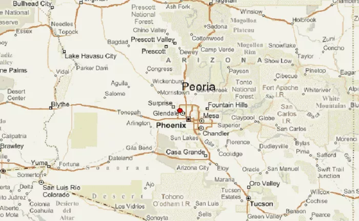
Peoria, Arizona is a thriving suburban city in the Phoenix metropolitan area, known for its excellent quality of life, recreational opportunities, and growing economy. Located in Maricopa County, Peoria offers easy access to both urban amenities and natural desert landscapes. This article examines Peoria’s exact location from multiple perspectives including geographic coordinates, regional context, transportation connections, and notable nearby landmarks.
Geographic Coordinates and Positioning
Peoria occupies a prime location in central Arizona with these precise geographic details:
Latitude and Longitude
Peoria’s city center is located at:
- 33.5806° N latitude
- 112.2374° W longitude
Elevation
The city sits at approximately 1,140 feet (350 meters) above sea level, typical of the Phoenix metro area’s elevation range.
Regional Placement
Peoria is situated about 14 miles northwest of downtown Phoenix. To visualize its position within Arizona, refer to this detailed USA Map.
Location Within Maricopa County
As part of Arizona’s most populous county, Peoria occupies the northwestern portion of Maricopa County with these characteristics:
City Boundaries
- Northern border: New River Mountains
- Southern border: Glendale
- Eastern border: Phoenix
- Western border: Sun City and unincorporated county land
Size and Area
Peoria covers approximately 176 square miles, making it one of the larger incorporated cities in the Phoenix metro area.
Transportation Access and Major Routes
Peoria’s location is well-served by multiple transportation options:
Major Highways
- Loop 101 (Agua Fria Freeway) – runs north-south through eastern Peoria
- State Route 74 (Carefree Highway) – connects to Lake Pleasant
- Grand Avenue (US 60) – historic route to Wickenburg
Public Transportation
Valley Metro bus service connects to Phoenix and neighboring cities
No light rail service (nearest station in Glendale)
Nearby Cities and Points of Interest
Peoria’s location places it near several important destinations:
Adjacent Cities
- Glendale (south)
- Surprise (west)
- Phoenix (southeast)
- Sun City (southwest)
Notable Nearby Attractions
- Lake Pleasant Regional Park (11 miles north)
- West Valley entertainment district (Glendale)
- Deer Valley Petroglyph Preserve
- Arizona Broadway Theatre
Economic and Demographic Significance
Peoria’s strategic location contributes to its development:
Population Growth
With over 190,000 residents, Peoria is one of Arizona’s fastest-growing cities, benefiting from its position northwest of Phoenix.
Key Employment Centers
- Peoria Sports Complex (spring training facility)
- Park West business district
- Healthcare corridor along 83rd Avenue
Comparison to Other Phoenix Suburbs
Unlike more urbanized suburbs closer to Phoenix, Peoria offers more open space and direct access to recreational areas. For broader context, compare Arizona cities on this States reference map.
Conclusion
Peoria, Arizona occupies a prime northwestern position in the Phoenix metropolitan area, offering residents and visitors easy access to both urban conveniences and outdoor recreation. Its location at 33.5806° N, 112.2374° W places it within convenient reach of major employment centers while maintaining a distinct suburban character. Whether you’re interested in spring training baseball, lake recreation, or suburban living, Peoria’s geographic position makes it an ideal choice in the Valley of the Sun.

