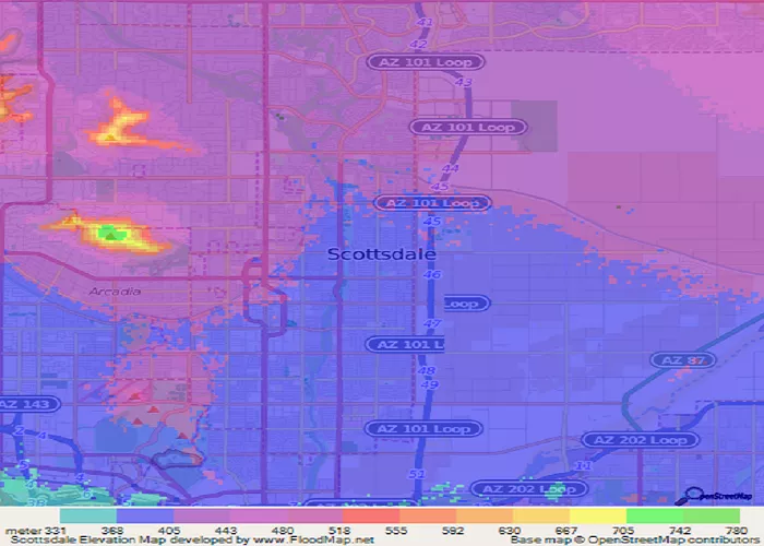
Scottsdale, Arizona is a vibrant desert city known for its luxurious resorts, world-class golf courses, and stunning Sonoran Desert landscapes. But beyond its glamorous reputation lies an interesting geographical feature – its elevation. Understanding Scottsdale’s elevation helps explain its climate, outdoor activities, and even real estate values. This comprehensive guide explores Scottsdale’s elevation from multiple perspectives, providing detailed information about how altitude affects life in this popular Arizona destination.
Basic Elevation Facts
Scottsdale’s elevation varies significantly across different parts of the city:
- Average elevation: Approximately 1,257 feet (383 meters) above sea level
- Lowest point: Around 1,100 feet near the Salt River on the western edge
- Highest point: Over 4,000 feet in the McDowell Mountains to the northeast
- Downtown elevation: Roughly 1,220 feet near Scottsdale Road and Camelback
- Foothills areas: Typically range from 1,500 to 2,500 feet elevation
Geographic Context
Scottsdale’s elevation fits into the broader geography of central Arizona:
- Compared to Phoenix: About 200-300 feet higher than neighboring Phoenix
- Valley location: Part of the Salt River Valley in the Sonoran Desert
- Mountain influences: McDowell Mountains to east create elevation gradient
- Regional comparison: Higher than Tucson (2,389 ft) but lower than Flagstaff (6,910 ft)
- Desert characteristics: Typical of USA Map Sonoran Desert basin elevations
Elevation Zones in Scottsdale
The city can be divided into distinct elevation zones:
- Western flats (1,100-1,300 ft): Older parts of city near Tempe border
- Central corridor (1,200-1,500 ft): Along Scottsdale Road corridor
- Foothills (1,500-2,500 ft): Popular residential areas with views
- Mountain areas (2,500-4,000+ ft): McDowell Mountains preserve lands
- Northern reaches (1,500-2,000 ft): Higher elevation as city extends north
Impact on Climate
Elevation significantly affects Scottsdale’s desert climate:
- Temperature variations: 3-5°F cooler per 1,000 feet elevation gain
- Heat relief: Foothills homes enjoy slightly milder summers
- Winter temperatures: Rare frosts more common at higher elevations
- Rainfall patterns: Slightly more precipitation in foothills areas
- Monsoon effects: Higher elevations may see stronger storm activity
Elevation and Outdoor Activities
Scottsdale’s varied elevation creates diverse recreation opportunities:
- Hiking trails: McDowell Sonoran Preserve offers elevation gains up to 2,000 feet
- Golf courses: Elevation changes create interesting course designs
- Cycling: Popular routes incorporate elevation challenges
- Hot air balloons: Operate at various elevations for different views
- Wildlife habitats: Different species at various elevations
Real Estate Considerations
Elevation affects property values and desirability:
- Foothills premium: Higher elevation homes command 20-30% price premiums
- View properties: Elevation enables panoramic city and mountain views
- Microclimates: Buyers pay for slightly cooler temperatures
- Construction challenges: Steeper slopes require special engineering
- Water access: Higher elevations may have different water systems
Health and Elevation
Scottsdale’s moderate elevation has health implications:
- Altitude effects: Minimal altitude sickness risk at this elevation
- Exercise benefits: Slight elevation can enhance athletic training
- Respiratory conditions: Dry air may help some respiratory issues
- Sun exposure: UV radiation increases about 4% per 1,000 feet
- Hydration needs: Desert elevation increases dehydration risk
Historical Development Patterns
Elevation influenced how Scottsdale grew:
- Original town site: Established at moderate elevation near canals
- Foothills expansion: 1960s-1980s saw development climb higher
- Mountain preservation: High elevation areas protected as open space
- Northward growth: City extended along natural elevation contours
- Resort locations: Many built at slightly higher elevations for views
Engineering and Infrastructure
Elevation differences create unique infrastructure needs:
- Water systems: Pressure management across elevation zones
- Road grades: Steeper roads in foothills areas
- Flood control: Drainage planning for elevation changes
- Construction techniques: Varied for different elevations
- Utility access: Challenges in highest elevation areas
Comparing Scottsdale’s Elevation
How Scottsdale stacks up against other destinations:
- Versus Phoenix: Consistently higher across entire city
- Versus Sedona: Much lower than Red Rock country (4,500 ft)
- Versus Denver: “Mile High City” is more than twice as high
- Versus Las Vegas: Similar base elevation but less variation
- Versus coastal cities: Much higher than sea level locations
Conclusion
Scottsdale’s elevation, averaging about 1,257 feet but ranging from 1,100 feet in the west to over 4,000 feet in the McDowell Mountains, creates a fascinating topographic diversity that influences everything from real estate values to outdoor recreation. The city’s moderate elevation contributes to its desirable climate, offering slightly cooler temperatures than Phoenix while avoiding the extreme altitude of Arizona’s mountain regions. Understanding Scottsdale’s elevation helps explain its development patterns, lifestyle advantages, and natural beauty. Whether you’re a homebuyer seeking foothills views, a hiker tackling mountain trails, or just curious about this desert city’s geography, elevation plays a key role in the Scottsdale experience. For more geographic details about Arizona and other States, consult comprehensive mapping resources.

