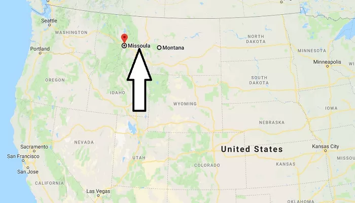
Missoula, Montana, is a geographically and culturally significant city in the American Northwest. Nestled in a valley surrounded by five mountain ranges, it serves as a hub for outdoor recreation, education, and economic activity in western Montana. This comprehensive guide examines Missoula’s location from multiple perspectives—geographical, cultural, economic, ecological, and infrastructural—providing an in-depth understanding of what makes this city unique.
Detailed Geographic Location
Coordinates and Topography
Latitude & Longitude: 46.8787° N, 113.9966° W
Elevation: 3,209 feet (978 meters) above sea level
Topography: Situated in the Missoula Valley, a glacially-carved basin surrounded by:
-
- Bitterroot Mountains (west)
- Sapphire Mountains (southeast)
- Garnet Range (northeast)
- Rattlesnake Mountains (north)
- Reservation Divide (northwest)
Hydrography
Confluence of Three Major Rivers:
-
- Clark Fork River (primary waterway)
- Bitterroot River (southwestern tributary)
- Blackfoot River (northeastern tributary)
Water Features:
-
- Nine artificial lakes within city limits
- Over 22 miles of riverfront within municipal boundaries
Regional Position
County: Missoula County (county seat)
Distance to Key Locations:
-
- 110 miles NW of Helena (state capital)
- 200 miles E of Spokane, WA
- 350 miles SE of Calgary, AB
- 450 miles NE of Portland, OR
Climate Zone
Köppen Classification: Humid continental (Dfb)
Annual Precipitation: 15.3 inches (389 mm)
Snowfall Average: 41 inches (104 cm)
Temperature Extremes:
-
- Record High: 107°F (42°C)
- Record Low: -33°F (-36°C)
Cultural Landscape
Historical Development
- Native American Heritage: Traditional lands of the Salish, Pend d’Oreille, and Kootenai tribes
- European Settlement: Established 1860 as Hellgate Trading Post
- Railroad Era: Became regional hub after Northern Pacific arrival in 1883
Educational Institutions
| Institution | Founded | Enrollment | Notable Programs |
|---|---|---|---|
| University of Montana | 1893 | 10,000+ | Wildlife Biology, Creative Writing |
| Missoula College | 1958 | 3,500 | Technical Education |
Arts and Entertainment
Major Cultural Events:
-
- International Wildlife Film Festival (since 1977)
- Montana Book Festival (annual)
- Downtown ToNight (summer concert series)
Public Art Installations: Over 150 permanent pieces citywide
Literary Significance
Home to:
-
- Richard Hugo (poet)
- James Welch (Native American author)
- William Kittredge (Western literature)
Literary landmarks:
-
- Fact and Fiction Bookstore
- Montana Festival of the Book
Economic Profile
Employment Sectors
| Sector | % Workforce | Major Employers |
|---|---|---|
| Education/Health | 32% | UM, Providence Health |
| Retail Trade | 15% | Southgate Mall, local businesses |
| Professional Services | 12% | Tech startups, legal firms |
| Government | 11% | City/County offices |
Emerging Industries
Outdoor Gear Manufacturing:
-
- 14% growth since 2015
- Companies: Rocky Mountain Outfitter, Snowbowl Ski Area
Technology Sector:
-
- 23 tech companies employing 1,200+
- Average salary: $72,000
Cost of Living Analysis
| Category | Comparison to National Average |
|---|---|
| Housing | 12% higher |
| Utilities | 8% lower |
| Transportation | 5% higher |
| Healthcare | 3% lower |
Ecological Systems
Biodiversity Hotspots
Rattlesnake Wilderness:
-
- 28,000 acres
- 50+ mammal species
- 120 bird species
Clark Fork River Corridor:
-
- Bull trout critical habitat
- 7 native fish species
Conservation Challenges
Urban Expansion Threats:
-
- 2.1% annual growth rate
- 15,000 acres of farmland lost since 2000
Climate Change Impacts:
-
- 2.1°F temperature increase since 1950
- 15% reduction in snowpack
Sustainable Initiatives
City of Missoula Climate Action Plan:
-
- 100% clean electricity by 2030
- 50% emissions reduction by 2035
Green Infrastructure:
-
- 45 miles of bike lanes
- 12 LEED-certified municipal buildings
Transportation Networks
Road Systems
Primary Routes:
-
- I-90 (Seattle-Boston)
- US-93 (Canadian border to Arizona)
- MT-200 (east-west corridor)
Traffic Data:
-
- 45,000 vehicles/day on Broadway Bridge
- 12% increase in bicycle commuting since 2015
Air Connectivity
| Airport | Destinations | Annual Passengers |
|---|---|---|
| MSO | 8 hubs | 800,000 |
| Nearby Alternatives: | ||
| BTM (Butte) | 3 hubs | 120,000 |
| GTF (Great Falls) | 4 hubs | 300,000 |
Public Transit
Mountain Line System:
-
- 12 fixed routes
- 1.2 million annual riders
- 100% zero-emission buses by 2025
Conclusion
Missoula’s strategic location at the crossroads of major river systems and mountain ranges has shaped its development as a cultural and economic center. The city balances urban growth with environmental stewardship, maintaining its reputation as one of America’s most livable small cities. From its world-class university to its thriving outdoor industry, Missoula continues to evolve while preserving its unique Montana character.

